Home • Resource Stewardship • Marine Use Planning & Management
Marine Use Planning & Management
image credit: Moonfish Media
Crab Closures
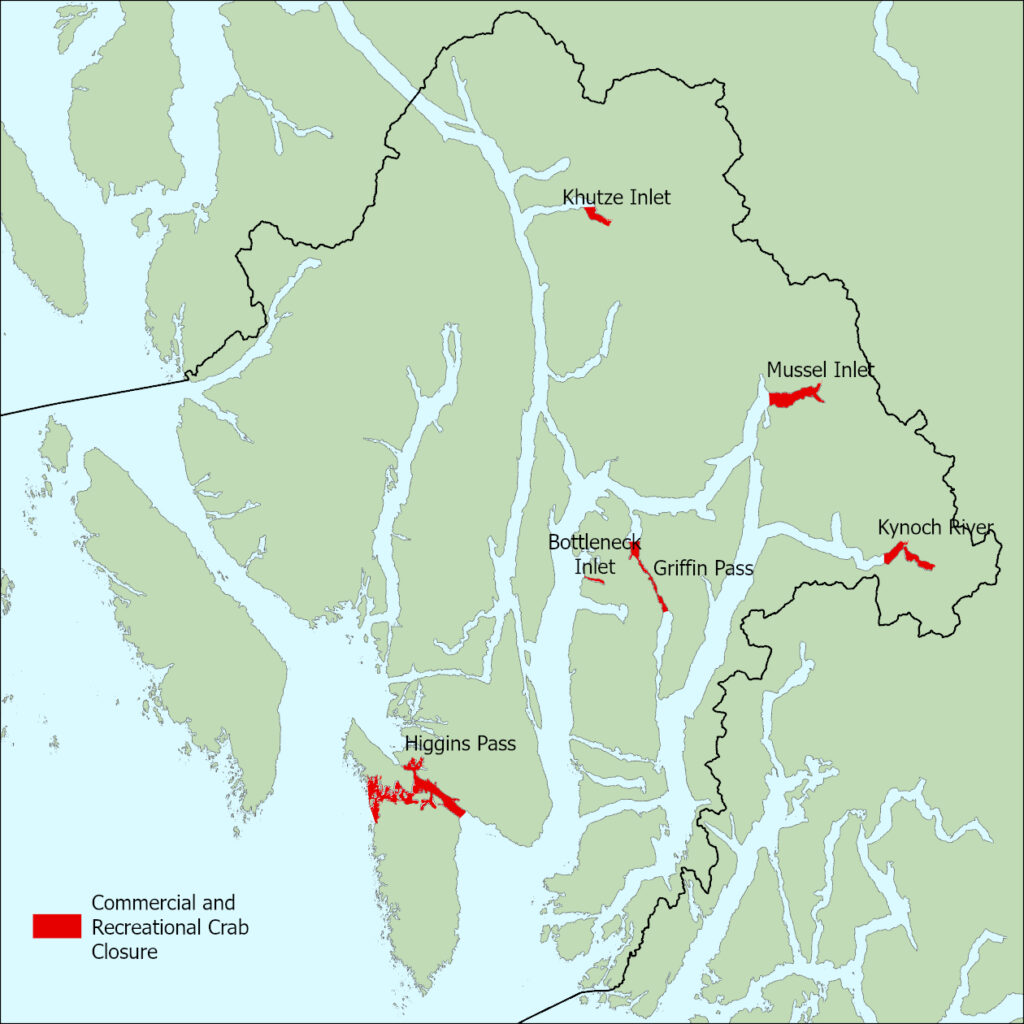
These are the six commercial and recreational crab closures in effect:
Mussel Inlet
Those portions of Mussel Inlet lying easterly of a line that begins at 52°54.608550’N 128°7.088569’W [Carse Point] then south to 52°53.891016’N 128°6.686082’W [east of David Bay]
Khutze Inlet
A portion of Subarea 6-23 lying southerly of a line that begins at 53°05.7887 TN 128°27.1974 TW [Pardoe Point] then to due east to 53°05.7865 TN 128°25.7469 TW.
Kynoch Inlet
The portion of Subarea 7-11 that is east of a line starting on the south shore at 52°44.5728 TN 127°57.9885 TW due north to a point at 52°45.0973 N 127°57.9743 W. This closure includes the eastern portion of Kynoch Inlet and Culpepper Lagoon.
Higgins Passage
Those portions of Subareas 6-16 and 7-3 lying inside of a line that begins at 52°29.074586′ N 128°45.836113′ W [southwest Swindle Island], then southwest to 52°28.658625′ N 128°47.783029′ W, then south to 52°27.752182′ N 128°47.957771′ W, then east to 52°27.505255′ N 128°45.896523′ W [west Price Island], then following the northern shoreline of Price Island to 52°27.564212′ N 128°37.583357′ W, then 52°27.919086′ N 128°36.925324′ W then following the southern shoreline of Swindle Island to the beginning point.
Griffin Passage
Those waters inside a line that begins at 52°46.0240 TN 128°20.9051 TW, then due east to 52 °46.0175 TN 128 °19.9661 TW then following the eastern shoreline to the south to the point 52 °40.5787 TN 128 °16.3566 W and then due west to 52°40.5787 TN 128°17.2617 TW and then following the west shore north to the beginning point.
Bottleneck Inlet
Those waters inside a line that begins at 52°42.7 TN 128°25.5 TW, then to 52°42.8 TN 128°25.5 TW, then following the shoreline back to the beginning point.
Working with the Central Coast Indigenous Resource Alliance (CCIRA), we engage government, industry, environmental organizations and other parties to implement our marine use plan and create further positive change in our territory. Mechanisms for realizing plan implementation include:
- Securing joint-management agreements with government to give the Central Coast First Nations’ jurisdiction and governing authority over our marine environment and its resources, which enable revenue and benefit sharing, and provides for equitable First Nations’ participation in economic development and capacity building
- Acquiring specific resource tenures and licences through government negotiation, existing programs, and market buy-back
- Developing partnerships with industry, environmental organizations and other third parties through memorandums of understanding, and impact-benefit or joint venture agreements
- Affirming Aboriginal rights and title to our lands and resources through treaty, litigation and other means, as appropriate